Grade 2

Scramble through lower scrub to gain tussock and then rock slopes to the summit. Descent was by East ridge which is a pleasant scramble. Climbed on Nicks 53rd Birthday.
Ross Cullen, Nick Shearer, April 2012.
Grade 2
Scramble through lower scrub to gain tussock and then rock slopes to the summit. Descent was by East ridge which is a pleasant scramble. Climbed on Nicks 53rd Birthday.
Ross Cullen, Nick Shearer, April 2012.
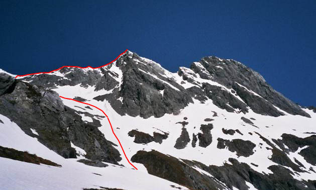
Grade 2.

From the saddle between Pk 2190 and Pakeke Peak, traverse under the NE face to gain tussock and then a rock scramble to the summit. Descent was by the same route.
Ross Cullen, April 2012.
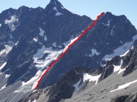
Access
From the lower Hopkins valley, cross the Hopkins river and ascend the scree-filled gully leading north east toward the summit of the outlier of Glen Lyon to access a 500m high apline rock slab.
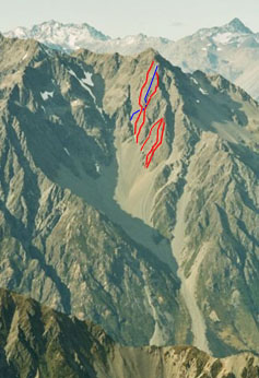

Climbs are described from left to right
Vote for Pedro (8-10 pitches, Crux Grade 15 – marked in blue)
Begin around 100m up into the gut, and climb the reasonably obvious diagonal corner to Dereks Escape Ledge at mid height. From there, climb the next pitch of Late Bloomer and traverse left (crux) to the arete. Climb two further pitches up the arete to the top.
Carl Schiller, Matteo Scoz, February 2008.
Tenderfoot (8-10 pitches, crux grade 14-15, alpine grade 3+)
Climb the slab from left to right, topping out near 1900m contour.
Paul Hersey, Mat Woods May 2004, Paul Hersey and Shelly Graham, completed February 2005
Late Bloomer (8-10 pitches, crux grade 17)
Mat Woods, Dave Morgan, February 2005.
Vote for Hillary (6 pitches, crux grade 14/15)
Six pitches to the outlier, short scramble and two abseils off.
Paul Hersey, Mat Woods, January 2007.
Chossy Mossy (4 pitches, crux grade 15)
Follow a wide crack followed by broken ledges just right of a huge overhanging scoop. Stemming crux is through overlaps.
Shelly Graham, Mat Woods, November 2005
Chicken Scoop (4 pitches, crux grade 16)
A four pitch climb that begins lower on the face. First pitch is a stunner, 40 metres of bomber incuts and high steps with just enough gear. One pitch scramble to the outlier summit and a 50m abseil to the exit gully.
Paul Hersey, Manfred Oswald, November 2005.
Racattack (300m, crux grade 15 – not yet shown on the photo). Starts near the lowest point of the SW face of Glen Lyon, well to the right of ‘Chicken Scoop’. Scramble up the ridgeline, keeping either on the ridge or just on its RHS when encountering difficulties. A couple of grade 15 pitches near the top, but otherwise easy scrambling. Finishes at the top of ‘Vote For Hillary’. Two abseils and down scrambling to descend.
Paul Hersey, Tony Rac, March 2012.
Grade 4, 9 pitches

The lower north face of Mt Hooker was climbed by Jamie Vinton-Boot and Shelley Hersey as part of the Backyard and Beyond project. Jamie reports that the quality of the rock is poor with little prospect of better quality rock elsewhere on the face. They finished at the hanging glacier at half height.
Jamie Vinton-Boot , Shelley Hersey, April 2012.
Grade WI3, M4, five pitches.

The route is to the right of Petit Peuterey and ascends the striking line on the southern (lower right) tier of the face, with sparse but adequate protection (all rock gear). The first ascentionists found thin ice and much of the rock rotten or blank, hence the lack of protection. The best descent is to abseil the route.
Jamie Vinton-Boot, Paul Hersey, September 2011.
Grade WI4, four pitches.

Lower Hopkins Valley
Honey Badger can be found in a secluded gully system on the east side of Rabbiter’s Peak. The lower part of the route is not visible in the picture above. Climb four long pitches, WI3-4. The best descent is to abseil the route.
Jamie Vinton-Boot, Paul Hersey, August 2011.
Grade WI4+, 2 pitches.

Bush Stream
Climb the centre of the three lines immediately above and right of the triangle-shaped buttress at the lower right side of the south face of Mt Brown.
Jamie Vinton-Boot, Nick Hanafin, July 2011.
Grade M5 WI4, 3 pitches.

Don’t Drop The Chandelier (June 11) in red, The Grrr Room in yellow (Aug 06), and descent route in blue
Main Branch, South Temple Stream
The route is on the lower tier of the SW face of Peak 2200m, starting at around 1500 metres. Three pitches starting immediately to the left of The Grrr Room. Cimb left, then right to join The Grrr Room on the final pitch, then onto upper snowfield. Descent down gully to right (marked in blue), may require multiple abseils depending on snow conditions.
Jamie Vinton-Boot, Paul Hersey, June 2011.
400m, Crux Grade 16

Access to the face is via the true left side of Thompson Stream starting from just below the terminal lake. Climb the face on reasonable quality rock to gain the ridge about 100m south of the summit. Descent is via the south ridge back to the glacier visible on the right of the photo. There is adequate protection for pitching. Soloed in around an hour by the first accensionist.
Jamie Vinton-Boot, February 2011
Around grade 12 rock

Forgotten is the line shown in green
Begin about 50 metres to the left of Bedazzled and follow a fairly straight line of slabs directly to the North Ridge, always left of Fly on Little Wing, Finish about 100 metres north of the summit. About grade 12 with limited protection.
Nick Cradock, Martin Hawes, February 2010
Tachycardia (2 pitches; 22, 23)
On Shindig through the Heart and finishes on Lunch edge.
Steve Carr, Jonathon Clearwater, November 2003
Hot Wings (1 pitch; 24)
On Wingers Wall
Bill Bradshaw, April 2004
Wrinkle Buttress, 0.5 hour downstream
English Summer Daze (3 pitches: 18, 18, 18)
Begin 100m upstream and uphill from the prominent bulgy face with a roof at top on true left of Twin Stream. Ledges at end of each pitch.
Steve Carr, Jonathon Clearwater, November 2003
Mr Fizz (3 pitches; 14, 15, 22)
First pitch angles right, second pitch climbs left, the two stars third follows a crack system.
Bill Bradshaw, Steve Carr. April 2004
January Hare (1 pitch; 16; 30m)
From the top of March Hare, climb the left face and arete to the top of the pinnacle. Protection is trad. Abseil off a bollard.
Cliff Ellery, Richard Knot, January 2009
Bladerunner (1 pitch; 20; 45m)
The base of the Shindig Gully is bordered by a spectacular arete. Climb the LH wall, and trend right to follow the arete to an outrageous step right onto the cantilevered nose at 35m, surrounded by air on all sides. Continue to DBB on ridgeline. The rock architecture is sensational. About 8B plus natural pro.
Dave Brash, Steve Carr, 2008.

These are the known routes on the north/west face of the Dasler Pinnacles. From left to right, the routes are Bestowed (red), Fly on little wing (winter ascent – yellow), Bedazzled (light blue), Flywheel (orange), Petit Peuterey D (dark blue). There may be additional routes and we do not have a lot of information on several of the indicated routes. if you have any additions, comments or corrections, please email them to barronbrewster@alpineclub.org.nz
Grade 2
The big south face contains a lot of features. Climb the steepening couloir from the head of Ahuriri /Hunter col. The route is 350m of mostly easy-angled terrain with a section of 50-60 degrees near top before the chossy ridge is gained 50m east of Peak 2414 metres.
Tony Clarke, Andrew Somervell, November 2008
Grade 2

Begin at the pronounced rock butress at NZMS498687 and follow the ridge to the reach a point just to the east of Pk1975. A rope may be needed in places on the lower section. It is easy to traverse off the ridge once above the lower butress.
Paul Hersey, Scott Blackford-Scheele, September 2008
Grade 3- (Crux grade 14)

Traverse around the north side of Awatea Peak to access Isabel-Awatea Col. From the col, climb the ridge for about 150m on excellent rock at around grade 10/11. A short, exposed, rising traverse at around grade 12 (one 45m pitch) leads to an easy ledge and the base of a short steep corner. The corner is the crux of the route and goes at about grade 14. From the top of the corner, about 130m of steep scrambling leads to the summit. Descent was via the NE ridge (the original ascent route) to the Isabel-Eric Col, then down a short icefall back to the base of the route. The divide ridge was appallingly loose rock over several steep towers and the first ascensionists did three short abseils to get through.
Rob Frost, Simon Mills, March 2008
Grade 1
Easy after breakfast walk up the valley due east of Top Hut.
Ross Cullen, March 2008
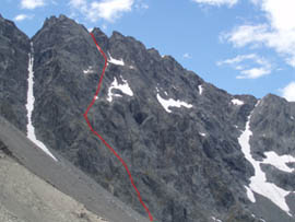
8 pitches, crux grade 16-17
South Huxley

The face is broken into two tiers separated by a 200m wide scree terrace. The lower tier is 3 pitches in length plus scrambling (crux grade 14) and the upper tier is 5 pitches plus scrambling (crux 16-17). The rock was variable in quality, but it is possible to pick a route which avoids the dark brown/black choss. The good rock on the steep upper tier was mostly light grey with vertical shallow seams and just enough protection. Descent was by the loose knife-edged ridge to the south east.
Tony Clarke, Hadley Slade-Jones, February 2008

West face of Stteple Peak, showing (left to right) Love Me Love My Zimmerframe, Wandering Flob, Zoe and Weta Prowl
Love Me Love My Zimmerframe (Grade 4-, Crux grade 16)
10-12 pitches on northern outlier of Steeple Peak. Begin at the lowest point of the outlier slab on the west side of Steeple Peak. Two pitches up through awkward corners (crux grade 16 with not much gear), then slight traverse left and up to a ledge at half height. Easier ground above (around grade 14) to top of outlier. Traverse down rock gully then across to link with the top pitches of Zoe.
Paul Hersey, Derek Chinn, January 2004
Wandering Flob (Grade 3+, Crux grade 16)
Six pitches plus some scrambling on fair to good rock and protection. Start in small corner approximately half way between Love Me Love My Zimmerframe and the right arete of the outlier of Steeple Peak. Tend left, then traverse towards the very left hand end of the obvious ledge system. Awesome belay spot here with good gear. From the ledge, tend slightly right for a full 60m up the solid wall with good gear, followed by a short pitch onto broken ground. Scramble upwards, following lines of weakness until 20m from summit, for one short exposed pitch to the summit.
Robert Hughes-Games, Flynn Battaerd, February 2008
Zoe (Grade 3+, Crux grade 17)
On north side of Steeple Peak outlier. Seven pitches left of Weta Prowl. Crux 17, mostly 12-14 climbing on great red greywacke with good protection.
Paul Hersey, Mat Woods, November 2003, and February 2005.
Weta Prowl (Grade 3+, Crux grade 14)
On the centre of the shorter right hand, west facing wall. Climb the slab at about grade 14 between the two rock flanges to the ridge crest, and follow it to the summit. 300m height gain, plenty of protection on excellent rock.
Ross Cullen, Bill McLeod, April 2002
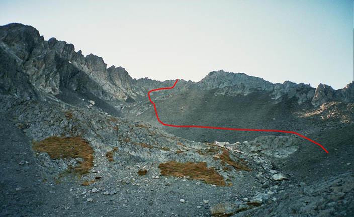
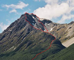
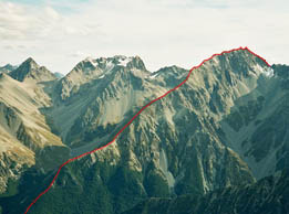
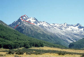
Grade 1
Peak 2230m from the NE. Red and blue lines show the ascent and descent routes, respectively.
Begin at G38 429723. Commence ascending the ridge via a weakness in the bluff (ledge or easy gully) to reach the broad tussock ridge at about 1300m. Gain height on the ridge turning steeper sections on the SE until reaching 2000m. Cross the ridge to the NW to reach top basin, traverse the snow and scree, and scramble up the rock pyramid to the summit. The kumara shaped tarn can be reached by descending the bluff below the upper basin, or by traversing from 1900m on the NE ridge to just above the tarn outlet.
Rob Blackburne, Ross Cullen, January 2008
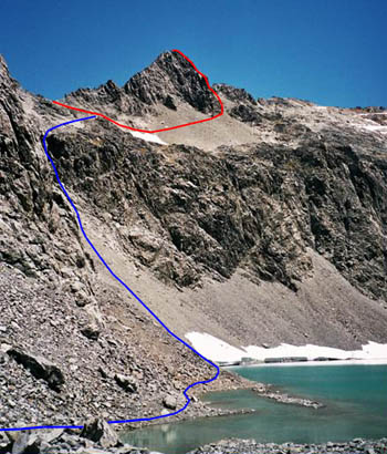
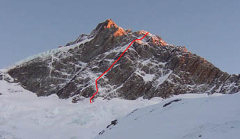
Grade 1
Glen Lyon from the south. Red and blue lines show the ascent and descent routes, respectively.
From the Dobson, follow the stream up to Waterfall Basin and then head south to gain the col at 1900m on the east ridge. Follow the ridge to the summit. The descent was made from the col via a gully system to the south keeping to the true left of the prominent ravine. Several small bluffs and head high scrub were encountered in the lower section.
Ross Cullen, Pip Lynch and Phil Doole, Jan 2008
Grade 1
Access the upper slopes via slopes just west of Cheap Creek. When near the summit pyramid, ascend snowfield then swing right to reach east ridge which is followed to the summit via steepish snow.
First ascent unknown, but climbed by Ross Cullen, Pip Lynch and James Barringer, December 2007.
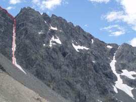
Grade 5, WI4
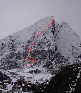
Start up the the obvious ice hose left of the summer line “Bedazzled“, then angle right up an easier snow slope to reach the big arete at about three quarters of the way up the face. Three pitches of hard mixed climbing up the arete to the summit. The first accent party took 17.5 hours to complete the climb from Daslers Bivouac.
Andrew Rennie and Tom Lanagan, July 2007
Grade 1

From the upper Dingle, travel up dry tributary valley under imposing south face to reach ridgeline. Easy travel along SW ridge overlooking Hunter valley to reach the summit pyramid. Head up centre till mid-height, then angle left on a ramp and follow easy ground to summit. Descent to north and large tarn in head of Dingle Burn
Ross Cullen, Pip Lynch, April 2007
Grade 3

Paradise Valley
Ascend the snow basin below the east ridge, then traverse onto shattered rock. Descent via the west ridge is on good but steep rock. The overall GT is about grade 4.
Shelley Graham, Graham Zimmerman, April 2007
Grade 1
Leave Ahuriri valley 1km north of Watsons Pond and climb through beech forest to gain the south west ridge. Ascend five of six rock steps en route to the summit.
Ross Cullen, Nick Shearer, February 2007
Grade 3+
West branch, South Temple Stream
Aim for a right tending ledge system that leads to a slab in the centre of the face. An eight pitch rock climb plus simul climb on reasonable rock, crux grade 14. To descend, head straight down the steep notch on the other side of the summit ridge for one pitch or abseil, then traverse left across broken rock down to easier ledges.
Dannie Baille, Paul Hersey, February 2007
Grade 4-
Ascend the obvious 700metre high spur on the south face to Mount Huxley’s eastern (2300m) summit. Crux grade 16, overall grade 4-
Danny Baillie, Paul Hersey, January 2007
Grade 3-
West branch, South Temple Stream
From the head of west branch South Temple stream, Climb the 40-55 degree narrow shute between Peak 2124m and Pakeke Peak to reach the ridge. Once on the ridge traverse easily to Peak 2124m. Stone fall is a possibility.
Paul Hersey, Mat Woods, November 2006
Grade 4+, WI3.

Paradise Valley
A 500m ice lyline on the south face, right side. Grade 4+, WI3. Follows a sustained gully system for eight to ten pitches starting at the valley floor and topping out on a spur below the east ridge.
Paul Hersey, Graham Zimmerman, September 2006.
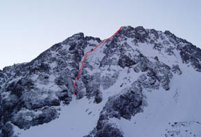
Grade WI2 to WI4, 6 pitches in total.
The Grrr Room in yellow (Aug 06), Don’t Drop The Chandelier (June 11) in red and descent route in blue
Main Branch, South Temple Stream
Just below west side of 2200m. Three pitches, first two thin, with tied off ice screws, a fat steep third pitch WI4, then onto upper snowfield. One abseil on descent down gully to right.
Paul Hersey, Matt Woods, August 2006.
Three pitches added to the bottom of the route. Climb the small water ice steps in the lower gully, that can fill in with snow later in the season.
Paul Hersey, Graham Zimmerman, July 2007.
Grade 2
South Huxley (south of Anita)
Straightforward rock scramble and short step snow gut. Grade 2.
Paul Hersey, May 2006
Up the Makarora River to the hut then west to Peaks 1971 and 2010 on the Main Divide. Return via Boundary Spur. Map ref: west corner of NZMS 260 G38.
Paul Hersey, Shelley Graham, Lydia Bradey, April 2006.
Grade 1
South Branch, South Temple Stream
Cross the south branch of the South Temple stream before the gorge, near 497694 on G38. Ascend the steep slope through the beech forest close to the crest of the ridge. Once open ground is reached continue along the ridgeline to the summit. The first ascent party did not use the rope. Seven hours from carpark to summit.
Ross Cullen, Nick Shearer, March 2006.
Grade 5+
Descending from Le Blanc Glacier, if the narrow gully is broken head on to a ledge on its true left (just above where the gully narrows). Three 50m abseils to valley floor. The bottom half of the buttress is actually two ridges which merge at half height. The left one (looking up) has better rock, easy soloing (grade 10) for 500m till reaching a snow shelf. Head up and start again up ramps on the upper buttress. Another 100m of solid grade 12 solo, then 500m of sustained grade 14-17 climbing (20+ pitches, we simul-climbed some sections). The technical crux is high on the route.
Overall, the climb increases throughout in technical nature and commitment, including very exposed summit ridge traversing. The rock is generally of good to very good quality with enough protection, although there are some loose plates high up.
Kynan Bazely, Paul Hersey, January 2006.
An obvious gully starts with water ice, 40 metre pitch then into 40-60 degree snow couloir heading up and right to the summit.
Shelly Graham and Yejin Tan, October 2005.
James Edwards and Sam Barron completed a winter ascent of a new line to the right of 42nd Street on the west face of Mt Huxley. The 800m high line goes up a big couloir and exits via some tricky ground just short of the summit where the pair spent the night in a hole. A pleasant introduction to New Zealand climbing for Sam, who was straight off the plane from the UK.
James Edwards and Sam Barron, September 2005.
1100m line to the left of Orinoco Flow, simul-soloed.
James Edwards, Steven Fortune, Paul Warnock, August 2005
North Huxley Valley
In the summer 2005, James Edwards and Oliver Metherell made the first recorded ascent of Peak 2072m, from the North Branch of the Huxley River. The route is 500m high.
James Edwards, Oliver Metherell, Summer 2005.
Grade 1-
From the pond near the mouth of Watson Stream in the mid-Ahuriri valley, climb through beech forest to 1200 m contour and follow south ridge toward summit. Complete short rocky scramble on east side to reach summit. Traverse north 1km past 2035m then descend via scree to reach valley near Hagens Hut.
First ascent unknown but John Barkla, Ross Cullen, January 2005.
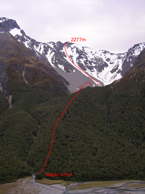
From 200m south of Hagens Hut, travel through the beech forest following a spur near Plughole Creek to reach the head of valley and climb couloir to the summit.
Alan Dorin, Rob Laery, Greg Robinson, January 2005.
Grade 1+
Ascend Little Canyon Creek and when at 1100m altitude, climb northward following a side stream to reach a shelf on east side of the peak. Climb up towards the summit pyramid and scramble to summit at grade 12/13 rock.
Matt Vandenberg, January 2005
Grade 4
Climb the obvious couloir in the centre of the south face. The first pitch is 45 m of steep and thin ice, followed by more moderate climbing. There are a couple of steeper ice steps before the gully reaches the ridge 20 m from the summit.
Kynan Bazely, Antony Bush, October 2004.
A 12 pitch climb that commences on a snowslope 100m right of the Blackburne-Cullen line. Climb through some mixed terrain to a right leaning snowslope. From there, a series of ice runnels lead straight up linking with the terrain at the top of Blackburne-Cullen route. Descended by downclimbing the north east face and onto Foster Glacier, with one abseil into North Elcho.
Kynan Bazely, Paul Hersey, August 2004
Grade 2
Jacks Stream
Begin in easy slanting gully on right hand side of the face. When the gully steepens and narrows, move onto the rock buttress on the left. Climb the rock for two pitches, grade 14 crux then ascend the upper snowfield to the summit.
Kynan Bazely, Paul Hersey, July 2004.
Grade ?
Paradise Valley
A four pitch ice climb through the left side of the lower tier.
Thomas Evans, Jackson Green, June 2004
Grade 3-
From Sutherland Stream, climb the central left leaning spur to the summit ridge, crux grade 15, grade 3-
Kynan Bazley, Yew-jin Tan, April 2004.
| Steven Fortune on Dasler Pinnacles, North-West F… | |
| Gerard on East Ridge, Taiaha Peak 2241m… |
